Sources of Information:
http://www.africamuseum.be/Nl/Departementen/Geologie/gars/bulusan.htm
Neumann van Padang, M., 1953, Philippine Islands and Cochin China. Catalogue of the Active Volcanoes
of the World, International Association of Volcanology, 2, Rome, Italy, 49 p.
Simkin, T., and Siebert, L., 1994, Volcanoes of the World: Geoscience Press, Tucson, Arizona, 349 p.
 Images of Volcanoes
 To VolcanoWorld
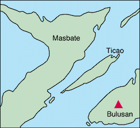
Mount Bulusan, Philippines Location: 12.8N, 124.1E |
Bulusan is an active stratovolcano and makes the extreme southeast part island of Luzon peninsula (bottom right of photo). The summit crater is 1,000 feet (300 m) in diameter and there are numerous lava flows on the flanks. There are three craters on the southeast flank; the lower two are crater lakes. The islands of Masbate and Ticao are to the southwest (top of photo). Bulusan has erupted at least 13 times since 1886, most recently in 1988. |
Bulusan Volcano
Bulusan Volcano is located at the south central part of Sorsogon Province. It covers a surface area roughly 400 sq. km. and towers to about 1559 m. above sea level. The volcano forms part of the
Bicol Volcanic Chain which stretches from Camarines Norte in the north to Sorsogon in the south. The chain, sometimes called volcanic belt, is composed of active and geologically young volcanoes most probably related to the Philippine Trench.
Bulusan is clasified as a composite volcano and is made up of lava flows and domes. It is flanked by several cones namely: Mt. Homahan, Mt. Binactan, Mt. Batuan, Mt. Juban, Mt. Calaunan, Mt. Tabon-Tabon, Mt. Calungalan and Mt. Jormajan.
Beside the active volcano is an old ridge called Sharp Peak which is 1215 m. high and 1.8 km. to the northeast. Between Bulusan and Jormajan is theNatakop lava dome. The earliest recorded eruption of Bulusan Volcano occured in 1852. This
was followed by periods of eruptive activity in 1886, then 1892, and in 1894. Another 22 years elapsed before Bulusan showed signs of restiveness. On January 16, 1916, the volcano ejected mud and ash for five days, thereby triggering
landslides. The volcano's eruptive activity from Oct. 1918 to March 1919 was characterized by dust emissions and lava outpourings. Bulusan's series of 17 eruptions during May 1919 to May 1922 were of short duration ranging from 15 to 30
minutes each. Other eruptions were recorded in June 1928 and Dec. 25, 1933 and then the volcano rested for 45 years. On June 28, 1978, it suddenly ejected ashladen steam clouds which formed in a dark column of smoke 1500 m. high. Andesitic
baalt ash was ejected and blown by winds to as far as Barcelona in the northeast about 15 km. from the volcano. The eruptions which followed in 1979, 1980, 1981 and 1983 were all pheatric and as mild as the previous ones. A total of 60
barangays within the territorial jurisdiction of six municipalities (Barcelona, Bulusan, Casiguran, Gubat, Irosin and Juban) are covered by the Bulusan Volcano hazard zones established by PHIVOLCS. These barangays lie within 4-10 km. from the
summit of Bulusan Volcano.
GEOLOGIC HISTORY
Luzon's southern most volcano, Bulusan, is constructed within the 11-km- diameter Pleistocene Bulusan (Irosin) caldera. It is 280 km NNE of Canlaon and 70 km SSE of Mayon volcano.
Historic Activity: Moderate explosive eruptions have been recorded since 1852. Between May 1918 and May 1922 there were 17 explosive, ash-producing eruptions, a lava flow, possible dome growth, and nuees ardentes. Intermittent explosions
during 1978-83 prompted some evacuations. Recent Activity:
Data Sources
http://users.bendnet.com/bjensen/volcano/asia/philippines/bulusan.html
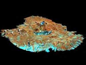
Perspective view of the Bulusan: A satellite image (Landsat TM) draped over a digital terrain model. http://www.africamuseum.be/Nl/Departementen/Geologie/gars/bulusan.htm |

Malapascua Island

Visayan Sea, Cebu, Philippines,