Pinatubo rose about 5725 ft ( 1745 m) above sea level before the June 1991 eruption. This means almost 500 ft (150 m) of the volcano was blasted away by this eruption. This seems to be the history of the volcano. After a relatively short explosive eruption, it will undergo a period of slow growth through extrusions. Then the volcano becomes dormant for a longer period, and much of the material deposited during the last eruption is eroded. Finally, another explosive eruption will occur and destroy whats left of the growth from the last eruptive period. This process seems to have repeated itself over time, creating a somewhat stable size for the volcano.
The largest eruption in the history of the modern Pinatubo occurred over 35,000 years ago. This eruption distributed over 325 ft (100 m) of pyroclastic flow material on all sides of the volcano. It also marked the birth of the modern volcano. The magnitudes of eruptions since that event are decreasing with time.
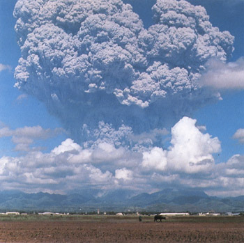
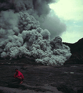
This photo depicts a secondary eruption on Mt. Pinatubo in May 1994.
This eruption lasted about four hours. Copyrighted photo by Marko Riikonen.
Pinatubo typically erupts large quantities of relatively cool ash and dacite magma. It follows that a large, shallow magma chamber exists beneath the volcano. When gas and crystal rich magma evolves in this chamber, explosive eruptions occur. There is great evidence of mafic magma mixing with the dacitic magma in these chambers causing these eruptions.
Pinatubo has been relatively quiet since the 1991-1992 eruption, but it is still active. It remains to be determined whether or not more explosions at the volcano are likely during the current eruptive period.

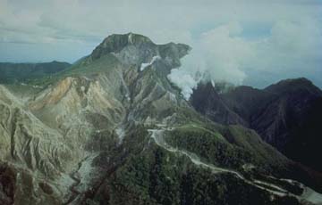
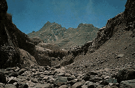
This photo shows a view of Mt. Pinatubo looking northeast at sunrise.
Copyrighted photo by Marko Riikonen.
ADDITIONAL IMAGES AND INFORMATION ABOUT MT. PINATUBO
- The Sleeping Giant Awakens
- Mt. Pinatubo prior to the 1991 eruption.
- Post Eruption Pinatubo
- Mt. Pinatubo Comparison
- False Color Image
- USGS Photos
ONLINE BOOK ABOUT MT. PINATUBO:
"Fire and Mud: Eruption and Lahars of Mount Pinatubo, Philippines"
Sources of Information:
Newhall, Christopher G. and Punongbayan, Raymundo S., Fire and Mud: Eruptions and Lahars of Mount Pinatubo, Philippines, Philippine Institute of Volcanology and Seismology, Quezon City and University of Washington Press, Seattle and London, 1126 pages, 1996.
 Images of Volcanoes
  To VolcanoWorld

Aschewolken Pinatubo, steigen bis 40 Kilometer hoch in die Stratosphäre.
Clark Airbase, versinkt in Asche
Kurze Zeit vor dem großen Ausbruch 1991. Galt bis zu diesem Zeitpunkt als ruhender Vulkan.
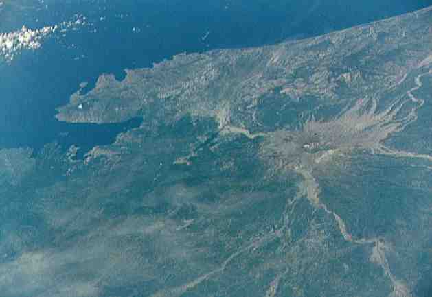
Spacefoto, Coastline Mount Pinatubo after Explosion
After the Explosion a lake has becoming from fallen rain
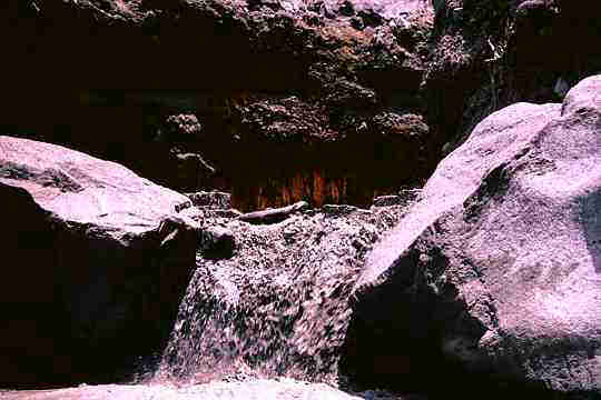
Muddy Waterfall, Mount Pinatubo
Mount Pinatubo |
This photo shows Mt. Pinatubo looking northeast. Copyrighted photo by Marko Riikonen.
Pinatubo is a stratovolcano on the island of Luzon. Its eruptive history is divided into two distinct parts. The first part of this history involves an ancestral volcano to Pinatubo. This period includes all eruptions to about 35 thousand years ago. Ancestral Pinatubo was a stratovolcano made of andesite and dacite. There is no evidence of large explosive eruptions from this volcano. Ancestral
Pinatubo was centered where the modern Pinatubo currently stands. It may have risen as high as 7550 ft (2300 m) above sea level at one time. Remains of a 2.2 by 2.8 mile (3.5 by 4.5 km) wide caldera from the old Pinatubo are still standing in the area today.
Several of the surrounding volcanoes were actually vents of the ancestral Pinatubo. These include the Mt. Negron dome, the Mt. Cuardrado dome, the Mataba dome and Bituin plug, and the Tapungho plug.
The modern Pinatubo is a dome complex and stratovolcano made of dacite and andesite. This complex is surrounded by pyroclastic flow and lahar deposits from large explosive eruptions. These explosive eruptions have been clustered into 6-12 eruptive periods. The explosive eruption of June 15, 1991 is one of the smallest of these eruptive periods. The 500 year period of dormancy that preceded this eruption was actually relatively short compared to other such periods in the history of the volcano.
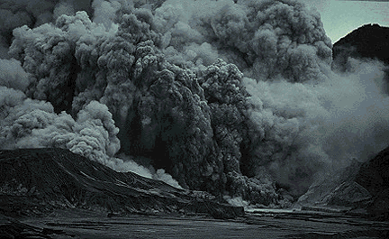
This photo shows a collapsed eruption cloud at the end of a secondary eruption in May 1994. The cloud is moving towards the camera.
Copyrighted photo by Marko Riikonen.
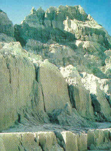
Ash walls, Mount Pinatubo from mud
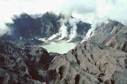
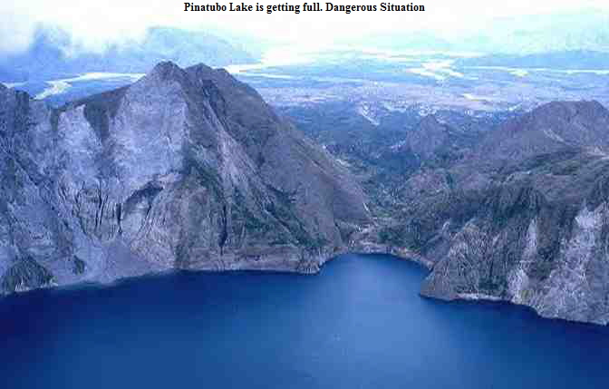
Pinatubo Lake is getting full. Dangerous Situation
Malapascua Island

Visayan Sea, Cebu, Philippines,