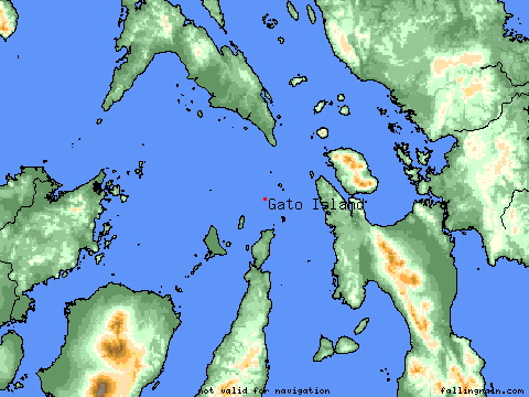
Gato
Carnassa
Maria Island
ManocManoc
Bohol
Leyte
Samar
Cebu
Negros
Masbate
Panay
Leyte
Cebu
Bantayan Isl.
Calangaman
Capitancillo
Visayas
Chocolate Isl.
Camotes
Bantayan
. Maya
Daan
Bantayan
The Visayan Sea around Malapascua Island
Guintacan
. San Isidro
.Bogo
.Santa Fe
Ormoc City.
Romblon Isl.
Sibuyan Isl.
Tanguingui
The Visayas
The Visayas, which are made up of Panay, Negros, Cebu, Bohol, Leyte, Samar and many smaller surrounding islands, boast some of the finest diving anywhere in the Philippines.
The Tresher Sharks and Manta Rays of Malapascua, the Hammerheads of Cabilao, the incredible walls of Pescador, the sunken island off Moalboal -- long a popular diver's destination -- and the incredible beauty of Apo Island, one of the country's first marine reserves, are typical of the rich variety and very high quality of diving to be found in the Visayas.
Panglao Island, a short distance from Tagbiliran, Bohol's capital city, is another favourite destination for diving enthusiasts. Panglao, with its many dive centres and stunning dive sites within a few minutes boat ride from golden beaches, is also a jumping-off point for many of the other islands like BALICASAG and sunken reefs throughout the area.
Mactan Island, adjacent to Cebu City, the Queen City of the South, is another popular scuba diver's haven. The many dive centres and dive resorts on Mactan (77 at last count) will arrange regular day excursions, liveaboard trips and diving safaris ro dive sites around this island as well as Olango, Hilatagan, Balicasag, Cabilao, Apo, Capitancillo, Gato and Calangaman islands. These places have some of the finest divesites you will find anywhere in the world, with breathtaking walls, stunning corals and endless varieties of marine life -- from the tiniest coral reef fishes to the "Oh my God!" variety of pelagics.
Boracay Island, to the north of Panay Island, is justly famous for its powder-smooth white sand beaches, but it also has some outstanding dive sites and over a dozen full-service dive centres operating along its gorgeous shores.
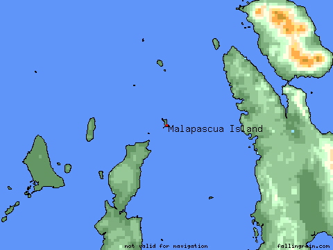
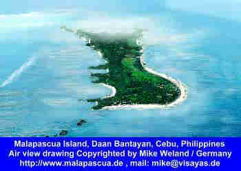
Malapascua Island, this tiny Island to the north of Cebu is a newcomer with his sparkling white beaches and nature island. The island is 2,5 kms long and about 1 km wide, with a
population at about 5,000. It has white sand beaches on the South and East Coast with crystal clear waters. The west coast is ideal for swimming and snorkeling but one should be careful because of unpredictable weather. A walk or tour on the
whole island can be done for about two hours..Malapascua is known worldwide for the only place where divers can watch the Tresher Shark on the near by sunken island MONAD SHOAL and Kimud Shoal
Mountain rises under
Visayan Sea
By Carlito Pablo
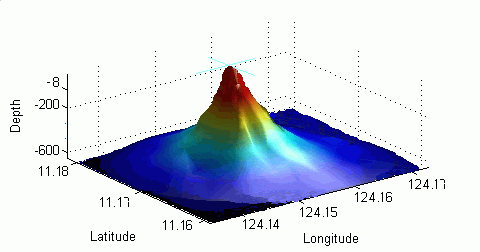
A MOUNTAIN-LIKE structure with an almost perfect cone, believed to be volcanic in origin, is growing beneath the surface of the Visayan Sea between Leyte and Cebu. Known as a seamount by oceanographers and geologists, the underwater structure--which appeared on mariners' maps only last year--is located approximately 12 kilometers off the coast of the town of Tabango, Leyte.
The natural edifice, now being referred to as the Tabango Seamount, rose by 10 meters from 1992 to 1997, according to a government inter-agency report. A survey by a team of Navy oceanographers last year ''confirmed the existence of a seamount rising from depths of 300 meters with an almost perfect cone with the peak at only 10 meters from the surface,'' said the report. In 1992, the peak was 20 meters below sea level.
The Department of Environment and Natural Resources said the seamount lies near the Philippine Fault. The presence of the fault bears directly on the mount's ''behavior in terms of growth and activeness.'' The government-owned BRP Hydrographer Presbitero will soon be dispatched to the area, carrying a team of scientists and surveyors from the Ocean and Littoral Group of the Philippine Navy, the Philippine Institute of Volcanology and Seismology, the Marine Science Institute of the University of the Philippines, the National Institute of Geological Sciences of UP, and the Bureau of Mines and Geosciences.
The team's mission: to determine the nature of the seamount, assess the causes of its vertical movement, and determine potential hazards posed by its growth. ''The immediate risks would be to navigation safety since the area is a ferry zone used by national and inter-island ships,'' Environment Secretary Antonio Cerilles said in a statement. The ship will be manned by personnel of the environment department's National Mapping and Resource Information Authority.
Mysterious
The seamount was first detected in 1992 when a Swedish contractor hired by the National Power Corp. conducted an oceanographic survey for a Leyte-Cebu power project. The company lost oceanographic equipment when the gear got snagged on a mysterious shoal-like structure. The structure was then surveyed by Napocor, which established the distance of the peak from the water surface. In 1997, when Napocor discovered that the seamount had grown in height by 10 meters, the Tabango mayor wrote the National Geographic Society requesting an investigation. The latter reportedly did not respond. The next year, a town resident wrote the US National Imagery and Mapping Agency with the same request, which was forwarded to the US Navy's Naval Oceanographic Office. The latter, in turn, referred the matter to the Philippine Navy. In August 1998, the team of Navy oceanographers and hydrographers was sent to investigate.
Volcanic formation?
Also that August, an international merchant vessel ran aground on the peak but managed to extricate itself. Almost exactly a year ago, the Namria published what it knew about the structure to guide mariners. On Dec. 16, 1998, the Navy initiated a round-table discussion on the matter with representatives. ''The discussion gravitated to the possibility that the seamount was volcanic in origin,'' the inter-agency report said. In a telephone interview, July Sabit of the Phivolcs monitoring center noted that while Leyte has several inactive volcanoes, the island of Cebu is principally made up of non-volcanic sedimentary formations. The seamount ''could be volcanic in origin or a mere growth in coral structures,'' Sabit said. ''We'll have to wait for further findings.''
--------------------------------------------------------------------------------------------
Location
Tabango is
situated at the northwestern quadrant of the province of Leyte in region VIII. It is located almost 130 kilometers from the airport in Tacloban City, which has daily flights to Manila and Cebu. The Ormoc City airport is forty-two kilometers southeast and has infrequent flights, mostly to Cebu City. Tabango is separated from its mother municipality of San isidro from the mouth of the brook immediately northeast of Sitio Arevalo, on Arevalo Bay and running easterly through the sitio of Abobo to the boundaries of San Isidro , Calubi-an and Leyte
; it is separated from the municipality of Leyte by the channel of the Naga River from its mouth to a point by strait line to the common point of the boundaries of San Isidro, Villaba and Leyte
.
.Tabango
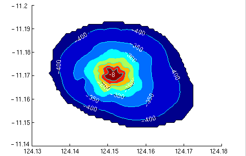
This is about the structure from the Tabango Underwater Mountain, also called Kimod Shoal.
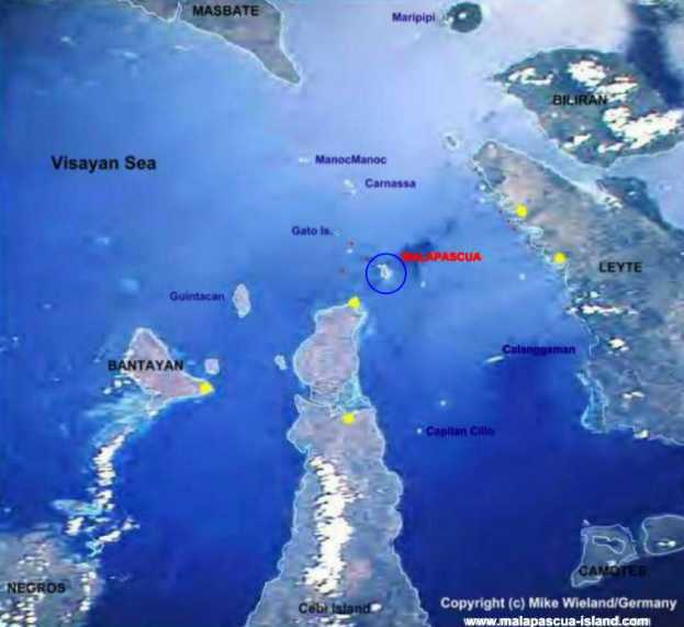
Malapascua
Capitan Cillo
Calanggaman
Copyright Mike Wieland / Germany www.malapascua-island.com
Maya
San Isidro
Tabango
Bogo
Visayan Sea A small sea located in the midst of the
Visayan Islands that comprise the central portion of the Philippines. It is centered at about 124 E and 12 N and connected to the Sibuyan Sea to the northwest, the Samar Sea to the northeast, the the Camotes Sea to the southeast,
the Bohol Sea to the southwest via the Tanon Strait, and to the Panay Gulf to the southwest via the Guimaras Strait. Prominent geographic features include the Asid Gulf (in Masbate Island) and Bantayan Island.
|
Tabango Underwater mountain, also called Kimod Shoal, only 8 meters (low water) under the surface, and it is still rising (2006),
124°15,00 Longitude
11°17,50 Lattitude
Malapascua Island

Visayan Sea, Cebu, Philippines,